Showing posts with label Lorong Halus Wetland. Show all posts

Saturday, June 21, 2014

Water quality of wetlands - Sengkang Floating Wetland

My name is J, and I am an undergraduate studying Environmental Studies in NUS. I will be starting on my honors thesis with my professor Dr. L this coming semester, and it is based on water quality monitoring at constructed wetlands-Sengkang Floatingwetland and Lorong Halus wetland. I have been reading your blog, and it has a lot of wonderful information very useful to me. I am still in the midst of my research before I start fieldwork, and I would like to ask you a few questions.

1. What are the parameters that you have measured in these wetlands before, and is it possible for me to obtain the data of these parameters? Considering the fact that I will be conducting some tests, a comparison with previous records of your data would be very useful.

2. Also, have you done a dissolved carbon analysis of the waters in Singapore/pCO2 analysis?

Thank you very much Sir!

Regards,
J


Hi J,

Glad that you like my posts. And I am happy to see that you are doing some field work at Sengkang Floating Wetland and Lorong Halus Wetland. I feel that not enough is being done to monitor the water quality in our water bodies.

1) I have not done any monitoring at Lorong Halus.

As for Sengkang Floating Wetland, I have conducted a workshop for teachers (1, 2) there in collaboration with PUB. No data was officially documented as that was a training workshop rather than a scientific monitoring session. But I have dug up a photo of the white board when the participants presented their results. See if you can make sense of it.

Figure: Results of water quality monitoring workshop at Sengkang Floating Wetland (11 Nov 2011)
 
 
2) No, I have not a dissolved carbon/ pCO2 analysis. My choice of parameters in water bodies is determined more by the demands of a healthy ecology. (Naturally, if I am working with drinking water or wastewater, the demands and thus parameters will be different.) In my opinion, dissolved carbon/ pCO2 are indirect parameters when it comes to water ecology as they reflect the interactions of water and geology more.  There are already so many parameters to monitor. No need to complicate matters or use up more resources unnecessarily :-)
 
Good luck!

Thursday, February 28, 2013

Question about Lorong Halus

Hello Chen Ko

My name is B and I came across your blog (http://waterqualityinsingapore.blogspot.sg/2011/04/latest-wetland-craze-lorong-halus.html) while trying to find out more about the health risks of running in the possibly leachate-containing mud trails near Lorong Halus landfill (I browsed your blog and I realise this might not be your area of expertise but I would appreciate any insight at all :-) ).


I live near to Sungei Serangoon and have recently started running at and exploring the area around Lorong Halus (it's an awesomely beautiful area with lots of wildlife - and I share your love of nature and I'm also concerned about how successful these new wetlands will be - the undeveloped east bank carries so much more biodiversity than the developed west bank which is Punggol Promenade and HDB flats).

On several trips recently I've been exploring the dirt trails that run along the east bank of Sungei Serangoon, and up and down one tributary just south of Lorong Halus Wetland (it leads up to Lorong Halus near the TPE entrance), and I've been running across what looks like leachate, especially near the green pumping stations:

1. Most commonly orange-ish puddles/mud similar to these:

http://www.soilenvironmentservices.co.uk/images/projects/7_landfill_leachate_metal_contamination.jpg

http://www.wolfenotes.com/2010/06/dep-calls-toxic-landfill-leachate-natural/

2. Oily rainbow sheen on puddles/mud

3. (least common) Black fluid leaching into some puddles

There's no way to avoid these so I've been getting my feet into them, and though I don't really intend to return to those trails in future, I was concerned about how toxic these are, and I was wondering if you have any idea? (I've done some googling and found that (as per your blog as well) the common hazards are heavy metals and toxic organics - PCBs and dioxins?) These areas are not open to the public currently, but there are trails used by foreign workers who fish there (probably from the dorm at Tampines Road near Old Tampines Road).

Here's thanks in advance for any advice you can provide. :-)

Best regards and happy trails!

B


Hello B,

First off, here is a quote for the purpose of Lorong Halus Wetland. "Using an innovative bio-remediation system, national water agency PUB designed the Lorong Halus Wetland to collect and treat water passing through the former landfill, preventing it from flowing into Serangoon Reservoir." (1, 2)

My stance is I would not say that leachate is escaping from the landfill without rock solid proof.

Unfortunately, environmental forensics is often a complicated and expensive activity. Imagine gathering numerous soil, water and solid waste samples from many locations and testing them using sensitive AND expensive equipment in the lab. When the data come out, you still have to interpret them to build up a useful case. One method is to obtain a chemical "fingerprint" of the liquid oozing out of the earth to match that of the solid waste in the landfill. Perhaps the solid waste has a very specific pattern of chemicals (this gives you the "fingerprint") not found anywhere else in the surroundings. If you can positively detect the same patternin your liquid, voila! Then you may have a case.

But we are talking about the environment here. Many physical, chemical and biological processes (both human and natural) are occuring at the same time and these can alter your "nice" pattern of chemicals in unpredictable ways.

Or perhaps you can't find any usable "fingerprint". All is not lost. Another method involves injecting a tracer chemical into your landfill and see if it ends up somewhere else in the surroundings. Obviously, this tracer should not already be in the environment and should be easily detected. A good tracer can be radioactive for ease of detection though it may not be so friendly to the ecology. Some applications have used your familiar salt as a tracer so if your streams suddenly turns salty, you know where it comes from. Same thing here - your ecology may not like such an influx of salt much.
Even if you can afford the time and money, at the end of the day, your tonnes of data may still be inconclusive to prove that leachate is indeed escaping from a landfill. I guess this is quite similar to criminal forensics in which your evidence is based on probabilities e.g. 95% confidence level. What is not to say that the heavy metals and toxic organics in your puddle could have come from the metal processing plant a kilometre away?
In response to your observations:
  1. "Orange-ish puddles/mud" are often caused by the presence of iron. Iron from soil (especially in Singapore soils) leaches out to the surface and form precipitates (orange solids similar to rust). This process can be facilitated by iron bacteria which "eat" (the chemical term is "oxidise") the iron for energy. Iron bacteria is easily identified by a orange/brown gelatinous slime.
  2. "Oily rainbow sheen" can indeed be due to oil, especially if there is iridiscence. But it can also be caused by iron/manganese particles from the soil. A simple way to find out is to use a stick to disturb the sheen. If the sheen breaks up into pieces, it is probably iron/manganese. If the sheen swirls around and follows your stick, it is probably oil. Even if it is oil, it can be from natural sources e.g. plants, dead animals.
  3. "Black fluid leaching into some puddles" can also be from nature. Is your fluid thick and viscous like engine oil? Or is it more like tea - black/brown yet clear? Tea coloured water can simply be tannins from decaying vegetation or humic substances (also originates from vegetation) from soil.

In essence, smoking gun evidence or even probable cause is hard to come by without further investigation and chemical testing. But if you ever find mass or sudden kill of plants or animals in the area, that is certainly a cause for concern though leachate may still not be the culprit.
Figure: Iron bacteria in a stream in Chinese Garden (Apr 2011). It can be a big aesthetic problem.

Figure: Iron bacteria in a small tributary at Ngee Ann Stream (Feb 2008). Even the vegetation were coated brown.

Figure: No, this is not sand. More iron bacteria on the canal bed at Ngee Ann Stream (Feb 2008)

Figure: Oil sheen on canal bed at Ngee Ann Stream (Feb 2008). Notice the iridiscence in the sheen.

Friday, March 30, 2012

Request for additional information about Punggol and Serangoon Reservoirs

* Parts of the email have been removed for conciseness*

I read with interest about the blog posts which you have made about the newly opened Punggol Reservoir as well as the overall knowledge that you have about water quality monitoring. Given your enthusiasm and expertise in this field, we hope that you will be able to furnish us with some of the details that we require, such as:


- An overall idea of the environmental monitoring process

- The critical parameters which are monitored and their baselines [understand from Greenspan that, for water, this includes: Dissolved Oxygen (DO), Temperature, Turbidity, pH, Conductivity, Chlorophyll-a and Nitrate (NO3)]

- How often/when are samples collected for testing?

- Are there any typical steps taken if the baseline conditions are exceeded?


It would be beneficial if some of the information are specific to the Punggol/Serangoon Reservoirs.

T


Like all other reservoirs on mainland Singapore, Punggol and Serangoon Reservoirs (PSR) are under the purview of PUB. The water quality in these reservoirs is definitely monitored though little detail has been publicised - type of water quality parameters monitored, frequency of monitoring, results and implications of the water quality data.

You may want to try the following reference books to find out more about water quality monitoring
  1. Water quality monitoring : a practical guide to the design and implementation of freshwater quality studies and monitoring programmes, edited by Jamie Bartram and Richard Ballance
    I find it useful as it covers the topic comprehensively though it may be slow reading at times. Published on behalf of United Nations Environment Programme, World Health Organization
  2. Water quality assessments : a guide to the use of biota, sediments, and water in environmental monitoring (2nd ed), edited by Deborah Chapman
    This is a follow-up to the above title. Again, useful and comprehensive. Published on behalf of UNESCO, United Nations Educational, Scientific, and Cultural Organization, WHO, World Health Organization, UNEP, United Nations Environment Programme

You are indeed right. Dissolved oxygen (DO), temperature, turbidity etc. are relatively easy to measure and hence routinely monitored, probably around once a week (my estimate, feel free to dispute).

I am sure many other parameters are also measured. (Just look at the WHO drinking water guidelines - they have about 200 parameters.) For example, heavy metals, pesticides, oil, volatile organic compounds (VOCs) are good bets. Even the fancy ones like dioxins and radioactivity are possible candidates. Of course, the frequency of monitoring of these chemicals (and radioactivity) depends on the cost and effort of analysis (e.g. expensive lab instruments or tedious lab preparation steps are needed), the likelihood of these chemicals existing in our reservoirs and their impact on health and environment. I won't be surprised if some of the fancy parameters are measured only once a year.

The parameters monitored in our reservoirs probably exceed those given in WHO drinking water guidelines. And PUB is probably going into biological monitoring using macroinvertebrates (bugs). Check out my previous post, Water trends in the next decade, for more information on this topic.

Figure: Serangoon Reservoir with a dam in the distance. The dam serves to separate fresh water in the reservoir from salt water in the sea.


Figure: Punggol Reservoir with Sengkang Floating Wetland in the foreground


For water quality monitoring  (WQM) in our reservoirs, setting up limits for the water quality parameters can be a bit tricky. Do we apply drinking water guidelines to reservoir water? Probably not.

Or do we apply guidelines for aquatic life? Countries such as USA, Canada etc. already have such guidelines. Do we use their guidelines? Again, probably not as the environmental conditions are quite different between Singapore and say, USA. Even if we develop our own guidelines, I am certain every reservoir will be different from one another e.g. geology. How do we factor these differences into our guidelines? Hence, I always believe that baselines for each reservoir will have to be established based on long term WQM. Any deviation from those baselines may then be further investigated. As far as I know, PUB's guidelines (if any) for reservoir water quality have never been publicised.

Thursday, April 07, 2011

Latest wetland craze - Lorong Halus Wetland

Wetlands seem to be all the rage in Singapore right now. With the launch of Sengkang Floating Wetland in November 2010, we now have the latest wetland launched (kinda reminds me of the incessant condominium launches in Singapore now) at Lorong Halus on top of our old landfill before Pulau Semakau took over. After talking to 2 staff from CUGE (Centre for Urban Greenery and Ecology), I found that there are many more wetlands being built all over our island, being part of experiments to clean up water.

Hey, don't get me wrong, I am all for installing constructed wetlands. If designed and managed well, they are effective in improving water quality (see post on using plants to clean up water). They are also pretty to look at, especially if the wetland attracts a diverse range of wildlife. Unlike artificial concrete and steel in a wastewater treatment plant (WWTP), a constructed wetland is mostly natural which is where its greatest appeal lies. (Though constructed wetlands are supposedly cheaper than conventional WWTP, I was told that our much publicised wetlands run into price tags of six figures or more. Perhaps, most of the cost went into paying the foreign expertise for design and possibly imports e.g. floating mats to make a floating wetland.)

The best thing about Lorong Halus Wetland (LHW) is it is not just a showpiece. It actually works! It functions as a treatment unit for leachate escaping from the former landfill at Lorong Halus. Leachate from a landfill can contain all sorts of nasty contaminants like heavy metals and toxic organics which can escape into the Serangoon Reservoir and subsequently into the water treatment plant.

What does the future hold?
I personally believe that constructed wetlands (a type of phytoremediation - defined as the use of plants to clean up soil and water) will become more widespread in the near future. As society becomes more environmentally conscious (what with the issues of climate change being publicised almost non-stop nowadays), people are starting to look for sustainable and environmentally friendly methods of treating wastewater. Even though constructed wetlands have their limitations (e.g. a need for land), their natural appeal and sustainable character are hard to beat. And if you are business minded, this is one natural technology that should not be overlooked as its market (especially in developing Asia) is set to grow. I will be writing more about this in future posts.

Back to LHW

Figure 1: PUB (Public Utilities Board) seems to releasing this watershed map of Singapore in recent projects. (Read more about how to interpret a similar map in post on Sengkang Floating Wetland.) Of particular highlight is the dark blue (also blown up as a circular insert above) area which delineates the watershed for Serangoon Reservoir.

Figure 2: Compare this old watershed map from PUB to the one in Figure 1. This old map split Singapore into only 3 catchment areas - East, Central, West. I believe this is more for adminstrative purposes (certain PUB departments are also split according to these 3 regions) rather than based on geography.
 Figure: The wetlands are in the upper part of the figure, consisting of reed beds (green with white dots) and polishing ponds (small patches of light blue).
 Figure: As in Sengkang Floating Wetland, there are ample signboards to educate the visitor about the site. Here, it explains why a constructed wetland is needed at Lorong Halus. (Answer: to clean up the leachate escaping from the landfill.)

 Figure: Another signboard explaining the need for polishing ponds after the leachate has gone through the reed beds. (Answer: the ponds are there to remove leftover nutrients and suspended particles.)
 Figure: In the distance, you can see the Serangoon East Dam which closes up Serangoon Reservoir. I imagine like most local dams, it only allows water to flow out and not in from the sea, hence, keeping the reservoir water fresh and preventing seawater from intruding.
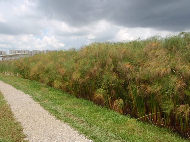
 Figure: One of the reed beds consisting of Papyrus. You probably find that this layout does not fit the definition of a wetland but it does or at least, it is defined as a constructed wetland. This type is known as HSSF (horizontal sub-surface flow) where the wastewater flows in the sub-surface via the plant roots where treatment takes place.
 Figure: Another reed bed, notice the gravel filling up the constructed wetland. This is advantageous because the wetland is "covered up", hence is aesthetically more acceptable - no unsightly wastewater and little offensive odours. Hey, you can even walk across the gravel bed as the gravel filling is well packed. Also the use of gravel allows the wastewater to flow underground easily through the empty spaces among gravel pieces.
Figure: A polishing pond. This design is also known as FWS (free water surface) as opposed to HSSF. By this time of the treatement process, the wastewater should be more or less cleaned since the reed beds have already done their dirty job of removing most contaminants. Therefore, an open water surface (or FWS) will be quite reasonable here.

(Update: you can find out more about how to clean up rainwater before it flows into our reservoirs in PUB's ABC (active, beautiful & clean) waters design guidelines. These guidelines advise developers and industry professionals to incorporate environment friendly features such as rain gardens, bioretention swales and wetlands in their developments.


Remember our watershed concept? Almost 70% of rainfall in Singapore lands in a watershed somewhere, ultimately ending up in our reservoirs. The plants and soil media employed in the above features act as “filters” to remove nutrients and sediments from the water going into our waterways.)